Gladys West Modelled The Earth So That We Can Have GPS
Gladys #Gladys

The name Gladys West is probably unfamiliar, but she was part of creating something you probably use often enough: GPS. You wouldn’t think a child who grew up on a sharecropping farm would wind up as an influential mathematician, but perhaps watching her father work very hard for very little and her mother working for a tobacco company made her realize that she wanted more for herself. Early on, she decided that education was the way out. She made it all the way to the Naval Surface Warfare Center.
While she was there she changed the world with — no kidding — mathematics. While she didn’t single-handedly invent satellite navigation, her work was critical to the systems we take for granted today.
Flying High
West had a passion for satellite altimeters. We think of a satellite being a certain height over the surface of the Earth, but that’s not really accurate. The Earth’s surface isn’t a smooth ball. Passing over a hill or a valley means that the exact distance from the surface to the satellite changes almost constantly. Passing over water is another problem. If you want to be precise, all these things matter. And if you want to build a Global Positioning System, you want to be precise.
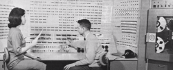
 West modeled the Earth’s exact shape based on data from the GEOS satellite. She later became the project manager for SEASAT, which used radar to measure the ocean surface. Her interest led her to work with the IBM 7030 computer to refine models of the Earth known as the geoid. This takes into account things like tidal forces and gravity to compute the true shape of the Earth, rather than simply assuming that it’s a perfect sphere. An accurate geoid is an important part of today’s GPS and similar navigations systems.
Full Ride
Her family did not have the money to send West to school, so she worked hard to earn a full scholarship. The top two graduating high school students got a full ride and through discipline and her intellect, graduated valedictorian in 1948.
She was excellent in all her subjects but elected to major in math. After a brief tenure teaching, she went back for a Master’s degree. Even with an advanced degree, though, teaching didn’t pay very well. Despite her trepidation in moving to Virginia during the 1960s, the Navy job offered her a better wage and she stayed in that job until retirement over four decades later.
Legacy
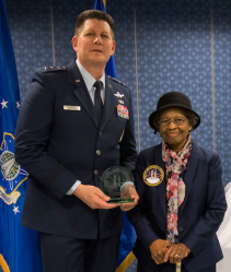
 West received several awards during her time at work. In addition, she was inducted into the Air Force Hall of Fame in 2018. The Navy even produced a short video that you can see below.
Of course, many people worked on GPS — known as NAVSTAR at its inception. It wasn’t even the first system of its kind. That honor probably goes to the 1960 Transit project. But all of these systems needed accurate mathematical models of the Earth, and West was a key part of the team that made that happen. Making accurate clocks, keeping them in sync, and shrinking all the components down with a low cost have their own stories and heroes, but for the math, we can thank Gladys West.
We like knowing the stories behind the tech we use every day. We think Gladys West is even more inspiring because of her humble beginnings and the obvious determination and intellect she had to carry her so far. Gladys got her PhD after she retired, but we understand she still prefers to use paper maps.
Want to know more about GPS? We can help. Just want to use it? We’ve come a long way from $3,000 handheld GPS units.