First Alert Weather: Patchy morning fog; Dry and warm Thursday
Good Thursday #GoodThursday

BIRMINGHAM, Ala. (WBRC) – Good morning and happy Thursday!
We are starting out the day with cooler temperatures compared to this time yesterday. Most of us are in the upper 40s and lower 50s. I definitely recommend grabbing a light jacket before you step outside this morning. We are tracking patchy dense fog in parts of central Alabama. We are seeing reduced visibility of a quarter of a mile or less in parts of west Alabama, Cullman County, and into St. Clair, Calhoun, and Talladega Counties. Please slow down if you encounter patchy fog. Most of the fog should dissipate by 9 a.m.
First Alert AccuTrack Satellite and Radar is showing us dry with a partly cloudy sky. We are watching our next rain maker develop to our west in parts of Texas, Oklahoma, and Arkansas. We will likely see a surge of moisture move into central Alabama starting tomorrow afternoon and continuing into Friday night. The good news is that we will remain rain-free today!
Out The Door Forecast(WBRC)
We are forecasting a partly cloudy sky with high temperatures climbing into the mid-70s. Winds will remain light today from the east at five to 10 mph. It should be a beautiful day to spend some time outside. Today would be a great day to clear out your gutters and storm drains. If you have any evening plans, we are looking at a mostly cloudy sky with temperatures cooling into the low-to-mid 60s by 7 p.m.

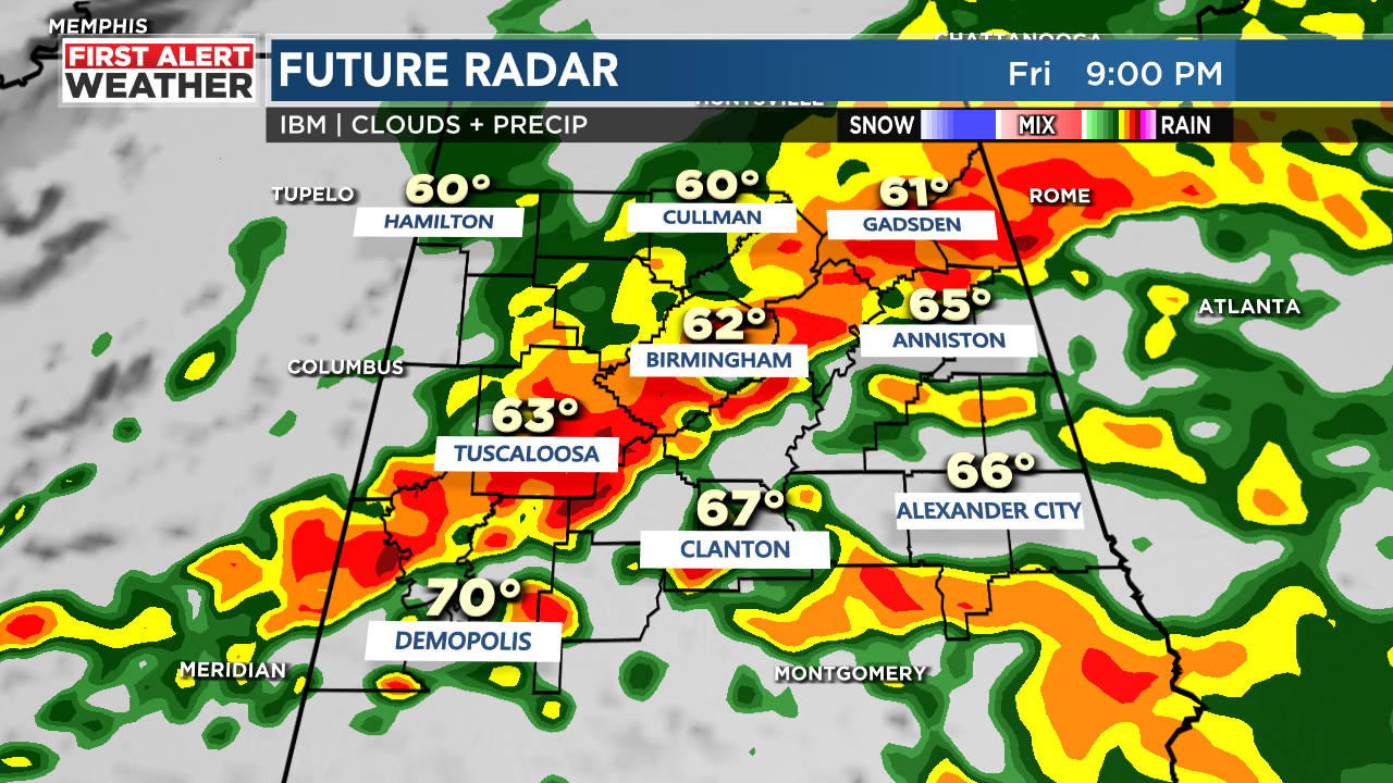
First Alert Weather Day: We have declared Friday evening into Saturday morning a First Alert Weather Day for the potential to see heavy rain, potential flash flooding, and a low-end threat for severe storms. Scattered showers and a few storms will be possible Friday afternoon, but the main threat will likely develop between 5 p.m. Friday through 9 a.m. Saturday.

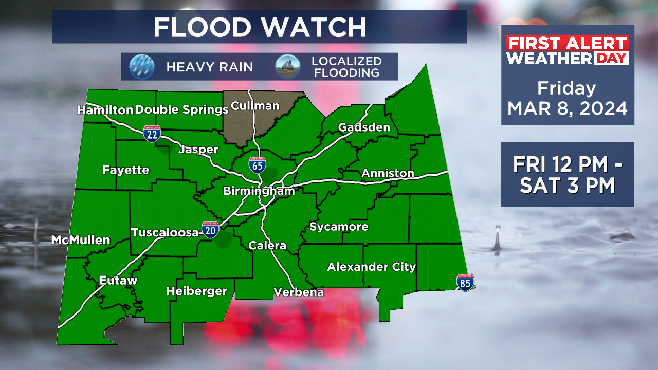
A flood watch has been issued for all of central Alabama starting Friday at noon. The watch expires on Saturday at 3 p.m. Rainfall totals of two to four inches will be possible across our area. We could see isolated totals of three to five inches south of Interstate 20. Remember to never drive through flooded areas. Turn around, don’t drown!
Severe Potential: We will have to watch areas along and south of Interstate 20 for an isolated severe threat. The main impacts include damaging winds up to 60 mph, large hail, and an isolated tornado.

Areas we will have to watch closely Friday evening into early Saturday morning include Sumter, Greene, Hale, Bibb, Tuscaloosa, Chilton, Coosa, and Tallapoosa counties. Areas farther north could see a strong or severe storm, but the heavy rain threat will likely limit the threat overall. I don’t anticipate any severe weather in parts of northeast Alabama where the atmosphere will likely remain stable. Please have multiple ways to receive warnings in case they are issued Friday night.
We will likely start tomorrow morning cloudy with a 20% chance for isolated showers. Temperatures will likely start out in the mid to upper 50s. We will end up cloudy and breezy tomorrow with showers and storms moving into northwest Alabama during the early afternoon hours.

Heavy rain and thunderstorms will increase in coverage across central Alabama during the evening and overnight hours. If you don’t have to travel on Friday evening, I would recommend staying home. It’ll be a messy evening and overnight commute. The stormy weather will likely continue into the midnight hours and slowly move out of the area by Saturday morning.
Weekend Forecast: We could see lingering showers Saturday morning, but we will likely dry out Saturday afternoon. Saturday morning will likely start out cloudy with a 40% chance for showers. Temperatures should remain mild in the upper 50s and lower 60s. High temperatures Saturday afternoon are forecast to warm into the upper 60s and lower 70s.
Weekend Outlook(WBRC)
Saturday will end up breezy as dry and cooler air moves into the state. We will likely see a partly cloudy sky Saturday night with temperatures cooling into the lower 40s. Sunday afternoon should end up cooler with highs in the upper 50s and lower 60s. Sunday afternoon looks to be breezy with a partly cloudy sky.
Daylight Saving Time begins: We want to remind you that we spring forward early Sunday morning!
Daylight Saving Time Begins(WBRC)
You’ll notice our sunrises will occur shortly after 7 a.m. Sunsets will now occur shortly before 7 p.m. Daylight will continue to increase as we approach summer. Sunrises will eventually occur before 6 a.m. going into May and June.
Frost possible Monday and Tuesday morning: With dry and cool air in place, we could see morning temperatures drop into the mid-to-upper 30s next Monday and Tuesday morning. It might be a good idea to cover and protect any blooming plants you have around the yard. The good news about the first half of next week is that we’ll stay dry. Temperatures will likely warm into the mid 60s Monday with a mostly sunny sky. Temperatures will trend warmer by the middle and at the end of the week with highs in the low to mid-70s. Pollen levels will likely remain high next week thanks to warm temperatures and recent rainfall.
Make sure you download the WBRC First Alert Weather app on Android and Apple devices for the latest weather information.
Have a great Thursday!
LATEST WBRC VIDEO
Get news alerts in the Apple App Store and Google Play Store or subscribe to our email newsletter here.
Copyright 2024 WBRC. All rights reserved.