First Alert Weather Day: More rain expected Thursday as flood watch continues
Good Thursday #GoodThursday
BIRMINGHAM, Ala. (WBRC) – Good morning and happy Thursday! We are continuing to watch the for the risk of flash flooding across central Alabama this morning.
THE NEXT 24 HOURS: We’ve declared a First Alert Weather Day through today for the threat of flash flooding.
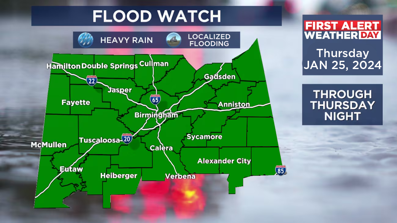
A flood watch will be in effect through 6 p.m. today as periods of heavy rain impact the area. An axis of steadier-heavy rain has impacted the state through much of last evening. We’ve already measured over two inches of rain in many areas and these totals will continue to add up through today. Once again, you may hear some loud rumbles as embedded storms will be possible. The risk of a severe storm is very marginal, but not completely zero today. The main concern will continue to be the threat for localized flash flooding. However, as temperatures rise, be alert for an isolated severe storm risk. The other big story is the major change in temperatures, with milder 50s to low 60s throughout the overnight.
I can’t promise many breaks in the wet weather over the next 24 hours. The next best chance for a break in the rain will happen late tonight and into Friday morning. That said, its still going to be cloudy and very damp, with some spotty showers/drizzle around. We are expecting another wave of rain materialize by Friday afternoon. The heavier rain looks to setup over southern areas, with showers further north.
THE WEEKEND: This soggy pattern is not forecast to end Friday as another wave of rain/storms will arrive on Saturday. This looks to impact most of the day, with rain reaching western areas by 6 a.m. Saturday and slowly transitioning east throughout the day. By the evening, this will be tapering off to lighter showers. The clouds will linger into Sunday, and we could see a stray shower or some sprinkles, especially to the northeast. Temperatures should be noticeably cooler on Sunday, with highs struggling to reach 50º.
Rain chance breakdown(WBRC FOX6 News)
We should have some clearing for the start of next week. Highs will be in the 50s, but we’ve trended colder at night, with the possibility of a light freeze Tuesday morning. If you are looking for the next big stretch of dry days, it looks like next week will cooperate.
Make sure you download the WBRC First Alert Weather app on Android and Apple devices for the latest weather information.
Have a nice day and stay dry!
Get news alerts in the Apple App Store and Google Play Store or subscribe to our email newsletter here.
Copyright 2024 WBRC. All rights reserved.