Cat. 4 Hurricane Idalia makes landfall in northern Florida. Here is what you need to know
Cat 4 #Cat4

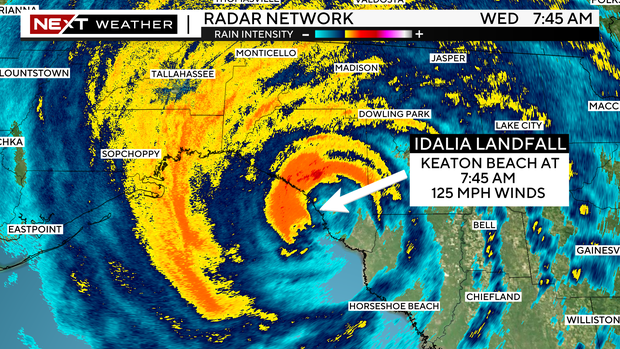
MIAMI – The massive Category 3 Hurricane Idalia has made landfall along Keaton Beach area in Taylor County. Keaton Beach is about 75 miles southeast of Tallahassee.
 Massive Hurricane Idalia
Idalia was briefly a Category 4 hurricane early Wednesday morning but lost some of its strength before landfall.
The storm came ashore around 7:45 a.m. with sustained winds of 125 mph as it moved to the north-northeast. As of the 8 a.m. advisory from the National Hurricane Center, the storm’s winds had dropped to 120 mph.
At 9 a.m., Adalia dropped to a Category 2 hurricane with sustained winds of 110 mph.
 Wet and windy NEXT Weather
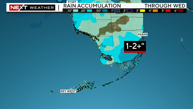
In South Florida, we will see gusty rain bands with the potential for 1-2 inches of rain with isolated higher amounts. It will be windy with gusts of 35 to 45 mph. Miami-Dade and Broward will be under a Wind Advisory from 10 a.m. to 7 p.m. On Thursday, the weather begins to improve with the potential for scattered storms.
Idalia is forecast to turn to the northeast and east-northeast, moving near or along the coasts of Georgia, South Carolina, and North Carolina late today and Thursday.
While Idalia will weaken after landfall, it is likely to still be a hurricane while moving across southern Georgia, and near the coast of Georgia or southern South Carolina late today. Idalia should emerge off the southeastern United States coast early on Thursday and move eastward through late week.
A Hurricane Warning is in effect for:
* Middle of Longboat Key northward to Indian Pass, including Tampa Bay*East coast of the United States from Altamaha Sound Georgia to Edisto Beach South Carolina.
A Hurricane Watch is in effect for:
* Mouth of the St. Mary’s River to Altamaha Sound* Edisto Beach, South Carolina to South Santee River, South Carolina
A Tropical Storm Warning is in effect for:* Chokoloskee northward to the Middle of Longboat Key* West of Indian Pass to Mexico Beach* Sebastian Inlet, Florida to Surf City, North Carolina*North of Surf City, North Carolina to the North Carolina/Virginia border, and Pamlico and Albemarle Sounds.
A Storm Surge Warning is in effect for:* Englewood northward to Indian Pass, including Tampa Bay* St. Catherine’s Sound to South Santee RiverA Storm Surge Watch is in effect for:* Bonita Beach northward to Englewood, including Charlotte Harbour* Mouth of the St. Mary’s River to St. Catherine’s Sound, Georgia* Beaufort Inlet to Ocracoke Inlet, North Carolina* Neuse and Pamlico Rivers, North Carolina
A storm surge in the Big Bend area could be up to 12 – 16 feet, in Tampa 4 – 6 feet, and 1 – 3 feet in southwest Florida.
Tropical storm conditions will continue within the tropical storm warning area along the Florida Gulf and west coasts.
Idalia is expected to produce a swath of 4 to 8 inches of rainfall with isolated maxima up to 12 inches from the state’s Big Bend area through central Georgia and South Carolina, and through eastern North Carolina into Thursday. These rainfall amounts will lead to areas of flash, urban, and moderate river flooding, with considerable impacts.
A few tornadoes are possible this morning across west-central and northern Florida into southeast Georgia.
More from CBS News
CBS Miami Team