First Alert Weather: Morning sunshine and cooler temperatures Thursday
Good Thursday #GoodThursday
BIRMINGHAM, Ala. (WBRC) – Good morning and happy Thursday!
It’s another chilly start to the day with temperatures generally in the 30s. It’s slightly cooler in west Alabama with temperatures near the freezing point. I highly recommend wearing a sweater and grabbing a coat before you step out the door today. With winds at 5 to 10 mph from the west, it will feel a few degrees cooler.
First Alert AccuTrack Satellite and Radar is showing cloud cover moving out of east Alabama and leaving us mostly clear and dry. I think we will enjoy plenty of sunshine for the first half of the day. By this afternoon, cloud cover will likely increase from west to east across central Alabama.
Hourly Forecast(WBRC)
Temperatures this afternoon will be noticeably cooler than yesterday with highs in the upper 40s. Winds today will continue from the west at 5 to 10 mph with gusts up to 15 mph this evening. If you have any evening plans, we will likely remain mostly dry. I can’t rule out a few sprinkles/flurries late tonight in parts of west Alabama as an upper-level disturbance pushes into the Southeast. We will likely end up partly to mostly cloudy this evening with temperatures cooling into the upper 30s by 8 p.m.

Small Chance for Light Rain/Flurries Friday: The big story tomorrow is the chance to see a few flurries or light rain showers across central Alabama.
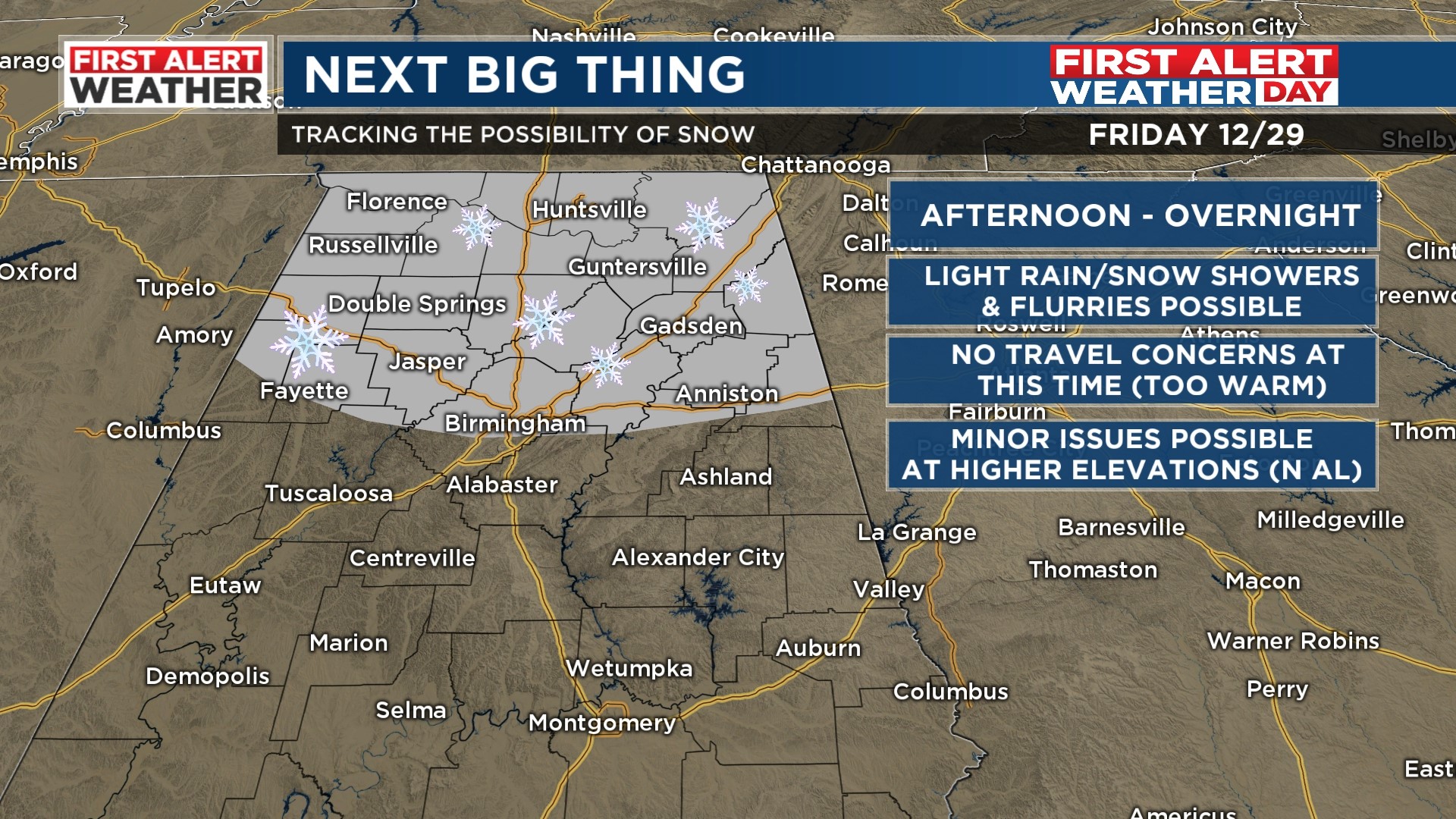
The best chance for light rain or a few snow showers will likely occur Friday evening and into Friday night. The areas that have the best chance to see precipitation will likely occur along and north of Highway 278. It includes locations like Marion, Winston, Cullman, Blount, Etowah, and Cherokee counties.
The latest trends are now hinting at less moisture with this upper-level low. I’ve kept a rain/snow chance at 30%, but areas south of Interstate 20 will likely remain dry. We continue a First Alert Weather Day for tomorrow, but if the trends continue, it’s very likely we will drop it as impacts look extremely minimal. We will likely start tomorrow morning off with an isolated shower or two with temperatures in the mid 30s.
Temperatures tomorrow are forecast to climb into the mid to upper 40s with a mostly cloudy sky. It will be breezy tomorrow with westerly winds at 10 to 15 mph with gusts up to 20 mph. Surface and ground temperatures will likely remain well above freezing, so I’m not expecting any travel concerns for us Friday night. Upper-level lows can produce surprises, so it’s very possible that it could trend slightly wetter. We will monitor the trends and give you continuous updates throughout today and tomorrow. Accumulations appear unlikely in this setup, but I can’t rule out a dusting in higher elevations on grassy surfaces for parts of North Alabama.
Dry and Cool Weekend: We will finish out 2023 with nice weather this weekend. We will likely see temperatures near the freezing point Saturday and Sunday morning. Both days should produce some sunshine with a few passing clouds. High temperatures Saturday will likely climb into the upper 40s and lower 50s. Sunday afternoon could end up a little warmer with highs in the mid 50s. Cloud cover will likely increase Sunday night, but I think we will bring in the new year dry. If you plan on being out for New Year’s Eve, dress warmly. We will likely end up in the upper 30s and lower 40s around midnight early Monday morning.
Showers Possible on New Year’s Day: Our weather models continue to show an area of low pressure developing in the Gulf of Mexico next Monday.
New Year’s Forecast(WBRC)
It will likely bring with it some showers across parts of the Southeast. The placement of the rain remains a big question. The GFS model shows a decent chance for a chilly rain across Central Alabama Monday. Meanwhile, the European weather model shows the best chance for rain impacting the southern half of the state. The track of the low will determine how much rain will impact central Alabama early next week. We’ll introduce a 30% chance for rain for areas south of Interstate 20.
Temperatures Monday afternoon will likely warm into the lower 50s with a mostly cloudy sky. Long-range models show temperatures remaining below average next week with another chance of rain next Wednesday-Thursday. High temperatures next week could stay in the low to mid 50s with overnight lows in the 30s.
Make sure you download the WBRC First Alert Weather app on Android and Apple devices for the latest weather information.
Have a great Thursday!
Get news alerts in the Apple App Store and Google Play Store or subscribe to our email newsletter here.
Copyright 2023 WBRC. All rights reserved.