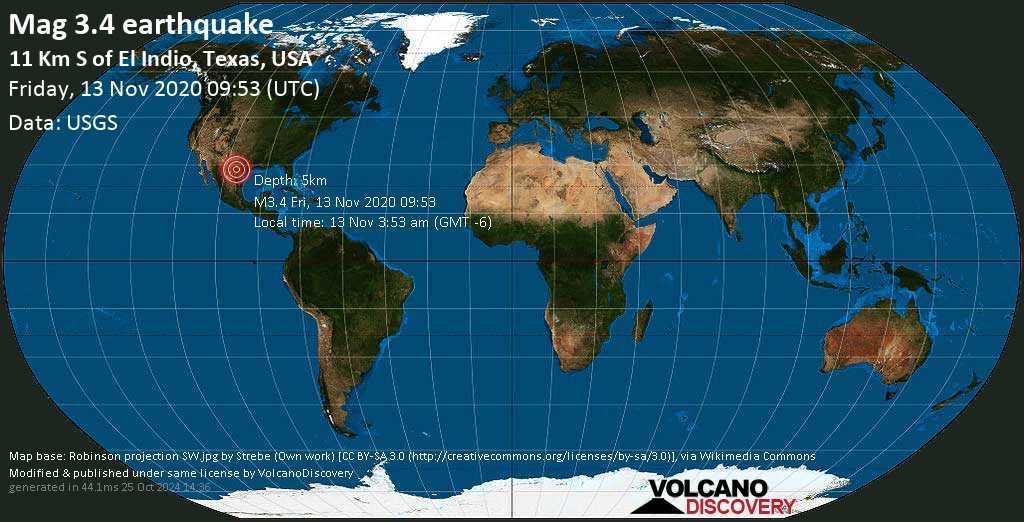
Minor magnitude 3.4 earthquake at 5 km depth
Vendredi 13 #Vendredi13

 Minor magnitude 3.4 earthquake at 5 km depth
13 Nov 10:03 UTC: Premier à signaler: EMSC après 10 minutes.13 Nov 10:03: Maintenant en utilisant une nouvelle source de données: USGS
Update Fri, 13 Nov 2020, 10:06
Small 3.4 quake hits near Eagle Pass, Texas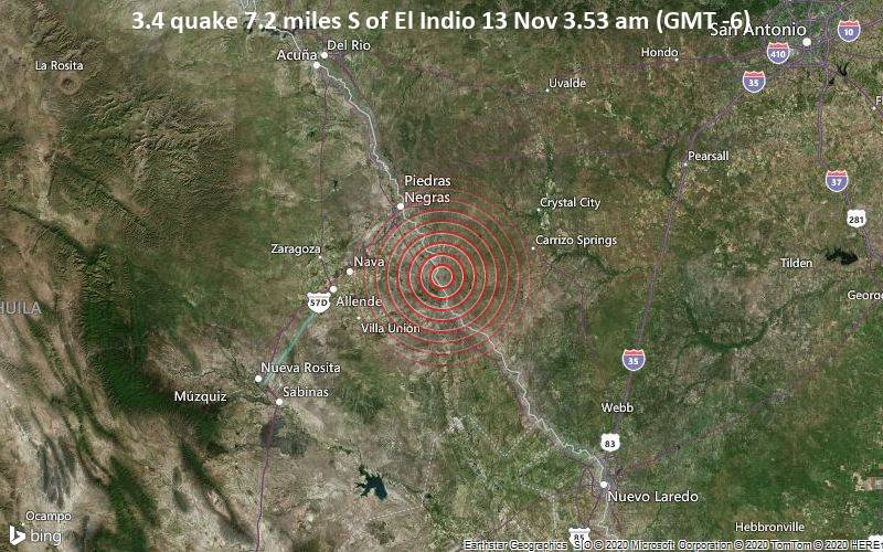
3.4 quake 7.2 miles S of El Indio 13 Nov 3.53 am (GMT -6)
Just 13 minutes ago, a 3.4-magnitude earthquake struck near the village of El Indio, Texas. The tremor was recorded early morning on Friday 13 November 2020 at 3.53 am local time, at a very shallow depth of 3.1 miles below the surface.The event was filed by the United States Geological Survey (USGS), the first seismological agency to report it.A second report was later issued by the European-Mediterranean Seismological Centre (EMSC), which listed it as a magnitude 3.4 earthquake as well.Based on the preliminary seismic data, the quake should not have caused any significant damage, but was probably felt by many people as light vibration in the area of the epicenter. Weak shaking might have been felt in El Indio (pop. 200) located 7 miles from the epicenter.Towns or cities near the epicenter where the quake might have been felt as very weak shaking include Eidson Road (pop. 9,000) located 21 miles from the epicenter, Eagle Pass (pop. 28,800) 24 miles away, and Carrizo Springs (pop. 5,900) 29 miles away.
If you were or still are in this area during the quake help others with your feedback and file a quick report here.
Download the Volcanoes & Earthquakes app to get one of the fastest seismic alerts online:Android | IOS Earthquake data:
I felt this quake
I didn’t feel it
Date & time: 13 Nov 2020 09:53:23 UTC – Local time at epicenter: vendredi, 13 nov. 2020 03:53 (GMT -6)Magnitude: 3.4Depth: 5.0 kmEpicenter latitude / longitude: 28.4077°N / 100.3143°W ![]() (États-Unis)Nearby towns and cities:10 km SE de Congregación Rodríguez (pop: 100)12 km S de El Indio (pop: 200)13 km NE de Guerrero (pop: 1000)128 km NW de Laredo (pop: 255,500)130 km NW de Nuevo Laredo (pop: 349,600)199 km NE de Monclova (pop: 195,800)Primary data source: USGSEstimated released energy: 7.9 x 10⁹ joules (2.21 megawatt hours, equivalent to 1.9 tons of TNT) [learn more] If you felt this quake (or if you were near the epicenter), please share your experience and submit a short “I felt it” report! Other users would love to hear about it!Also if you did NOT feel the quake although you were in the area, please report it! Your contribution is valuable also to earthquake science and earthquake hazard analysis and mitigation efforts. You can use your device location or the map to indicate where you were during the earthquake. Thank you! Data for the same earthquake reported by different agencies
(États-Unis)Nearby towns and cities:10 km SE de Congregación Rodríguez (pop: 100)12 km S de El Indio (pop: 200)13 km NE de Guerrero (pop: 1000)128 km NW de Laredo (pop: 255,500)130 km NW de Nuevo Laredo (pop: 349,600)199 km NE de Monclova (pop: 195,800)Primary data source: USGSEstimated released energy: 7.9 x 10⁹ joules (2.21 megawatt hours, equivalent to 1.9 tons of TNT) [learn more] If you felt this quake (or if you were near the epicenter), please share your experience and submit a short “I felt it” report! Other users would love to hear about it!Also if you did NOT feel the quake although you were in the area, please report it! Your contribution is valuable also to earthquake science and earthquake hazard analysis and mitigation efforts. You can use your device location or the map to indicate where you were during the earthquake. Thank you! Data for the same earthquake reported by different agencies
Info: The more agencies report about the same quake and post similar data, the more confidence you can have in the data. It takes normally up to a few hours until earthquake parameters are calculated with near-optimum precision.
Heure Mag. / Depth Location Source 13 Nov 2020 09:53:23 GMT13 nov. 2020 03:53 (GMT -6) 3.45 km 12 km S de El Indio USGS 13 Nov 2020 09:53:23 GMT 3.45 km SOUTHERN TEXAS, USA EMSC User reports for this quake Contribute:Leave a comment if you find a particular report interesting or want to add to it.Flag as inappropriate.Mark as helpful or interesting.Send your own user report! There are no user reports for this quake yet. If you felt it be the first to report it! Earlier earthquakes in the same area Minor mag. 3.4 earthquake – 7.2 miles S of El Indio on Friday, 13 Nov 3.53 am (GMT -6)
Click here to search our database for earlier earthquakes in the same area since 1900!
Plus sur VolcanoDiscovery 
Do you know which is the biggest volcano in the world?